Gulf of Mexico is the eleventh largest body of water in the world. Considered a smaller part of the Atlantic Ocean, it is an ocean basin largely surrounded by the North American continent and the island of Cuba. It is bounded on the northeast, north and northwest by the Gulf Coast of the United States, on the southwest and south by Mexico, and on the southeast by Cuba. The shape of its basin is roughly oval and approximately 810 nautical miles (1,500 km) wide and filled with sedimentary rocks and debris. It is part of the Atlantic Ocean through the Florida Straits between the U.S. and Cuba, and with the Caribbean Sea (with which it forms the American Mediterranean Sea) via the Yucatan Channel between Mexico and Cuba. With this narrow connection to the Atlantic, the gulf experiences very small Tidal ranges. The gulf basin is approximately 615,000 mi² (1.6 million km²).
Almost half of the basin is shallow intertidal waters. At its deepest it is 14,383 ft (4,384 m) at the Sigsbee Deep, an irregular trough more than 300 nautical miles (550 km) long. It was probably formed approximately 300 million years ago as a result of the seafloor sinking.
Geology and Deep Structure.

Sediment in the Gulf of Mexico Little is known about the geologic history of the Gulf of Mexico Basin before Late Triassic time. Some authors have postulated the presence of a basin in the area during most of Paleozoic time, but most evidence seems to indicate that Paleozoic rocks do not underlie most of the Gulf of Mexico basin and that the area was, at the end of Paleozoic time, part of the large supercontinent of Pangea, the result of the collision of several continental plates.
The present Gulf of Mexico basin is believed to have had its origin in Late Triassic time as the result of rifting within the North American Plate as it began to crack and drift away from the African and South American plates.
P-Wave Tomography Deep Structure.
P-Wave Tomography Deep Structure (Wave Tomography along the Middle American Trench
Rob Rogers, Hrafnkell Karason, and Rob van der Hilst, 3, 2002 ):
Rifting probably continued through Early and Middle Jurassic time with the formation of "stretched" or "transitional" continental crust throughout the central part of the basin. Intermittent advance of the sea into the continental area from the west during late Middle Jurassic time resulted in the formation of the extensive salt deposits such as the Louann Salt. It appears that the main drifting episode, during which the Yucatan block moved southward and separated from the North American Plate and true oceanic crust formed in the central part of the basin, took place during the early Late Jurassic, after the formation of the salt deposits.
Since Late Jurassic time, the basin has been a stable geologic province characterized by the persistent subsidence of its central part, which probably came about first because of thermal cooling and later because of sediment loading as the basin filled with thick prograding clastic wedges along its northwestern and northern margins, particularly during the Cenozoic.
To the east, the stable Florida platform was not covered by the sea until the latest Jurassic or the beginning of Cretaceous time. The Yucatan platform was emergent until the mid-Cretaceous. After both platforms were submerged, the formation of carbonates and evaporites has characterized the geologic history of these two stable areas. Most of the basin was rimmed during the Early Cretaceous by carbonate platforms, and its western flank was involved during the latest Cretaceous and early Tertiary in a compressive deformation episode, the Laramide Orogeny, which created the Sierra Madre Oriental of eastern Mexico.
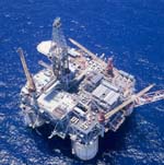
Oil Rigs

The Gulf of Mexico is an excellent example of a passive margin. The continental shelf is quite wide at most points along the coast, most notably at the Florida and Yucatán Peninsulas. The shelf is exploited for its oil by means of offshore drilling rigs, most of which are situated in the western gulf and in the Bay of Campeche.