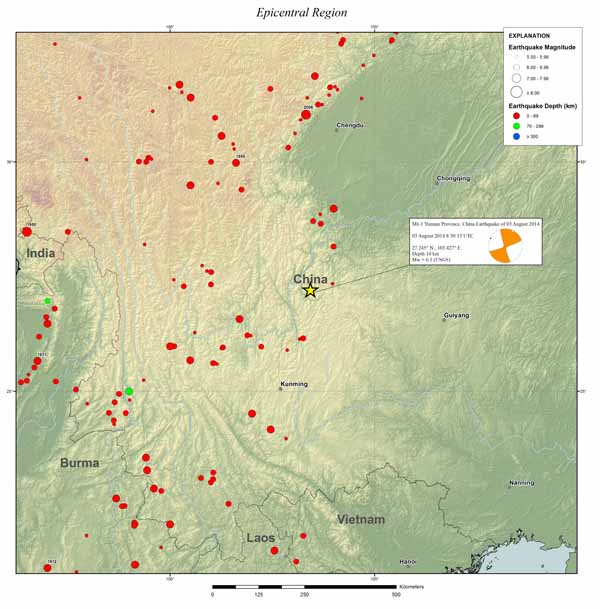
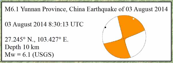
Quake time: August 3, 2014, 08:30:13 UTC
Quake location: NW of Wenping (Yunnan Province, China).
Magnitude/Depth: M6.1 / 11km
Earthquake occurred because of shallow strike-slip faulting within the crust of the Eurasia plate. Tectonics of this region are broadly controlled by the convergence of the India plate with Eurasia.
|
|

|
|
China is a country of intense midland seismicity. Most earthquakes in China occur within the interior of the Eurasian plate.
|
Focal mechanism of the Yunnan earthquake.
|
Simplified map of major geological units in continental China and their relative motion (mm/yr) with respect to stable Siberia, based on Quaternary fault-slip rates and other neotectonic data (Ma, 1989; Deng et al., 2002). Thin lines are active faults. WG—Weihe graben; SG—Shanxi graben; YR—Yinchuan rift; HR—Hetao rift; BB—Bohai Basin.
|
The India plate has driven the uplift of the Himalayas to the west of this earthquake, and has caused the formation of numerous intraplate continental transform structures in the surrounding region, including the left-lateral Xiaojiang fault system.
Local deformation rates in the region of this earthquake indicate as much as 10 mm/yr of left-lateral shear.
.")
|
P-wave velocity variations at four cross sections along the Burmese arc from north to south, where EHS-eastern Himalayan syntaxis, TV-Tengchong volcano.
From: Chang Li, Robert D. van der Hilst, Anne S. Meltzer, E. Robert Engdahl. Subduction of the Indian lithosphere beneath the Tibetan Plateau and Burma.
Earth and Planetary Science Letters, Volume 274, Issues 1–2, 30 September 2008, Pages 157-168
|
At the latitude of the August 3 event, India moves northwestward with respect to Eurasia at a rate of approximately 51 mm/yr.
Strong earthquakes are reasonably common in Yunnan, and bordering Sichuan; the area within 500 km of the August 3 earthquake has hosted 27 other earthquakes of M 6 or above over the past century.

Yunnan Province Earthquakes are often damaging and deadly. This region is an agricultural province with a high population density. Nearby earthquakes in the M5-6 range in April 1985, October 1995, November 2003, August 2004, and August 2006, all caused fatalities – the largest (October 1995, M 6.2) resulted in approximately 50 deaths. In May 1974, a M 6.8 earthquake 115 km to the northeast of the August 2014 quake caused approximately 1,540 fatalities and a similar number of injuries.
The reports indicate this M 6.1 event has caused close to 400 fatalities, 1,800 injuries and the destruction of at least 12,000 houses, some due to landslides that have resulted from the earthquake and heavy rainfall.
Significant Earthquakes in China.