2015 Nepal earthquake, Himalaya.
Table of contents.
Introduction.
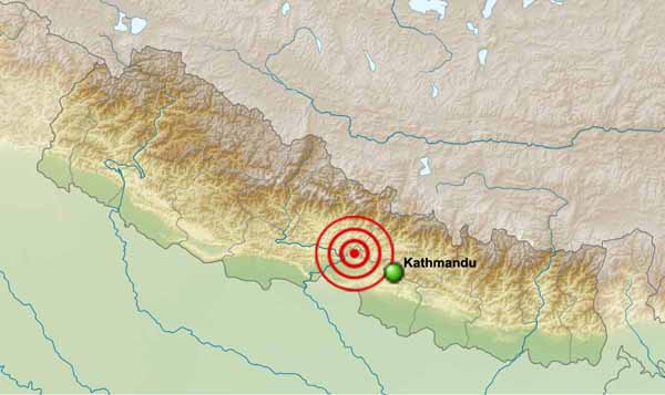
The 2015 Nepal earthquake (the Himalayan earthquake), occurred at 11:56 NST (06:11:26 UTC) on 25 April (M = 7.8).
The epicenter was approximately 34 km east-southeast of Lamjung, Nepal (28.147°N 84.708°E).
The hypocenter was at a depth of approximately 15 km.
It was the most powerful earthquake to strike Nepal since the 1934 Nepal–Bihar earthquake.
The earthquake was initially reported as 7.5 Mw by the United States Geological Survey (USGS) before it was quickly upgraded to 7.9 Mw and finally downgraded to 7.8 Mw. The China Earthquake Networks Center (CENC) reported the earthquake's magnitude to be 8.1 Ms. The India Meteorological Department (IMD) said two powerful quakes were registered in Nepal at 06:11 UTC and 06:45 UTC. The first quake measured 7.9 Mw and its epicenter was identified at a distance of 80 km to the northwest of the capital Kathmandu. The second earthquake was somewhat less powerful at 6.6 Mw. The seismic focus lay at a depth of 10 km below the earth's surface. Bharatpur was the nearest major city to the main earthquake, 53 km (33 mi) from the epicenter. The second earthquake occurred 81 km (50 mi) northwest of Kathmandu, the capital of Nepal. Over thirty-five aftershocks of magnitude 4.5 Mw or greater occurred in the day following the initial earthquake, including the one of magnitude 6.6 Mw.
According to the USGS, the temblor was caused by a sudden thrust, or release of built-up stress, along the major fault line where the Indian Plate, is diving underneath the Eurasian Plate.
The capital Kathmandu situated on a crust's block 120 km wide and 60 km long. This crust block shifted 3 m to the south in just 30 seconds.
Some casualties reported in the India, China, and Bangladesh.
The earthquake triggered an avalanche on Mount Everest, in Langtang valley.
Centuries-old buildings were destroyed at UNESCO World Heritage sites in the Kathmandu Valley, including some at the Kathmandu Durbar Square, the Patan Durbar Square and the Bhaktapur Durbar Square.
Continued aftershocks occurred throughout Nepal, with one shock reaching a magnitude of 6.7 on 26 April at 12:54:08 NST. Nepal is at continued risk of landslides as well.
To Top
Geology and Tectonic Summary.
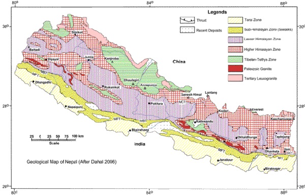
Nepal lies towards the southern limit of the diffuse collisional boundary where the Indian Plate underthrusts the Eurasian Plate, occupying the central sector of the Himalayan arc, nearly one-third of the 2,400 km long Himalayas. Geologically, the Nepal Himalayas are sub-divided into five tectonic zones from north to south, east to west and almost parallel to sub-parallel. These five distinct morpho-geotectonic zones are:
- Terai Plain;
- Sub Himalaya (Sivalik Range);
- Lesser Himalaya (Mahabharat Range and mid valleys);
- Higher Himalaya;
- Inner Himalaya (Tibetan Tethys).
Each of these zones is clearly identified by their morphological, geological, and tectonic features.
The convergence rate between the plates in central Nepal is about 45 mm per year. The location, magnitude, and focal mechanism of the earthquake suggest that it was caused by a slip along the Main Frontal Thrust.
The earthquake's effects were amplified in Kathmandu as it sits on the Kathmandu Basin, which contains up to 600 m (2,000 ft) of sedimentary rocks, representing the infilling of a lake.
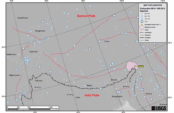
The April 25, 2015 M 7.8 Nepal earthquake occurred as the result of thrust faulting on or near the main frontal thrust between the subducting India plate and the overriding Eurasia plate to the north. At the location of this earthquake, approximately 80 km to the northwest of the Nepalese capital of Kathmandu, the India plate is converging with Eurasia at a rate of 45 mm/yr towards the north-northeast, driving the uplift of the Himalayan mountain range. The preliminary location, size and focal mechanism of the April 25 earthquake are consistent with its occurrence on the main subduction thrust interface between the India and Eurasia plates.
Large earthquakes on the Himalayan thrust are rare in the documented historical era. Just four events of M6 or larger have occurred within 250 km of the April 25, 2015 earthquake over the past century. The largest, an M 8.0 event known as the 1934 Nepal-Bihar earthquake. A study from 2015 suggests that because of tectonic stress buildup, the earthquake from 1934 in Nepal and the 2015 quake are connected, following a historic earthquake pattern.
To Top
Intensity.
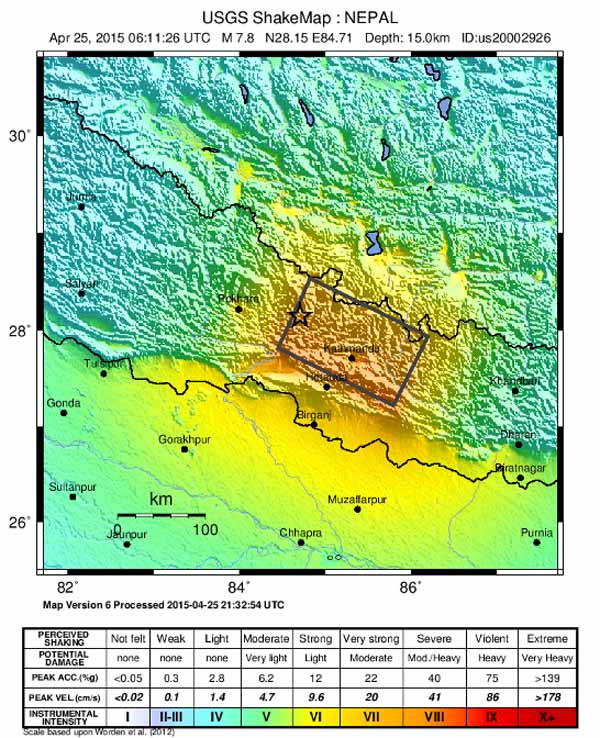
According to "Did You Feel It?" (DYFI?) responses on the USGS website, the intensity in Kathmandu was IX (Violent). Tremors were felt in the neighboring Indian states of Bihar, Uttar Pradesh, Assam, West Bengal, Sikkim, Uttarakhand, Odisha, Andhra Pradesh, Gujarat, in the Indian capital region around New Delhi and as far south as Karnataka. Many buildings were brought down in Bihar. Minor cracks in the walls of houses were reported in Odisha. Minor quakes were registered as far as Kochi in the southern state of Kerala. The intensity in Patna was V (Moderate). The intensity was IV (Light) in Dhaka, Bangladesh. The earthquake was also experienced across southwestern China, ranging from the Tibet Autonomous Region to Chengdu, which is 1,900 km (1,200 mi) away from the epicenter. Tremors were felt in Pakistan and Bhutan.
To Top
Aftershocks.
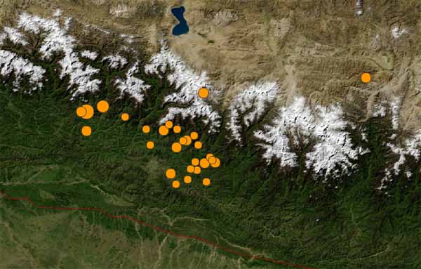
A major aftershock of magnitude 6.7 Mw occurred on 26 April 2015 in the same region at 12:55 NST (07:09 UTC), with an epicenter located about 17 km south of Kodari, Nepal. The aftershock caused fresh avalanches on Mount Everest and was felt in many places in northern India including Kolkata, Siliguri, Jalpaiguri and Assam.
The aftershock caused a landslide on the Koshi Highway which blocked the section of the road between Bhedetar and Mulghat.
A model of GeoGateway, based on a United States Geological Survey mechanism of a near-horizontal fault as well as location of aftershocks showed that the fault was an 11° dip striking at 295°, 50 km (31 mi) wide, 150 km (93 mi) long, and had a dip slip of 3 m. The USGS says the aftershock on Sunday registered at a shallow depth of 10 km (6.2 mi).
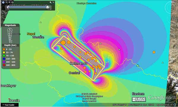
Initial model of the M 7.8 Nepal earthquake as may be seen by an Interferometric Synthetic Aperture (InSAR) spacecraft such as Sentinal-1 or ALOS-2 and GPS. The model is based on USGS mechanism of a near horizontal fault and the location of aftershocks. This image shows a synthetic interferogram for a descending pass of –168°, 24 cm wavelength, elevation of 40°. Fault is 11° dip striking 295°. Maximum displacement vector is about 2.3 m. Color wrap is 24 cm per fringe.
Assuming that this earthquake is the largest event in this seismic episode, Nepal can expect more than 30 aftershocks greater than magnitude 5 over the next month.
To Top
Seismotectonics of the Himalaya and Vicinity.
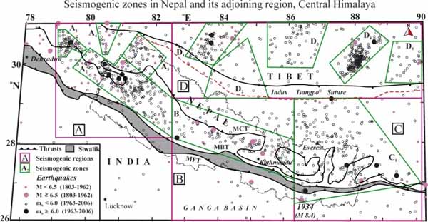 Main central thrust (MCT), Main boundary thrust (MBT), Main frontal thrust (MFT) and Indus Suture (ITS) are the major tectonic features in the region. The great earthquake of 1934 is located to the south of the MFT. A, B, C and D represent seismic regions that have been delineated based on spatial distribution of distinct seismicity as compared to the surrounding region.
Seismicity in the Himalaya dominantly results from the continental collision of the India and Eurasia plates, which are converging at a relative rate of 40-50 mm/yr. Northward underthrusting of India beneath Eurasia generates numerous earthquakes and consequently makes this area one of the most seismically hazardous regions on Earth. The India-Eurasia plate boundary is a diffuse boundary, which in the region near the north of India, lies within the limits of the Indus-Tsangpo (also called the Yarlung-Zangbo) Suture to the north and the Main Frontal Thrust to the south. The Indus-Tsangpo Suture Zone is located roughly 200 km north of the Himalaya Front and is defined by an exposed ophiolite chain along its southern margin. The narrow (<200km) Himalaya Front includes numerous east-west trending, parallel structures.
This region has the highest rates of seismicity and largest earthquakes in the Himalaya region, caused mainly by movement on thrust faults. Examples of significant earthquakes, in this densely populated region, caused by reverse slip movement include the 1934 M8.0 Bihar, the 1905 M7.5 Kangra and the 2005 M7.6 Kashmir earthquakes. The largest instrumentally recorded Himalaya earthquake occurred on 15th August 1950 in Assam, eastern India. This M8.6 right-lateral, strike-slip, earthquake was widely felt over a broad area of central Asia, causing extensive damage to villages in the epicentral region.
To Top
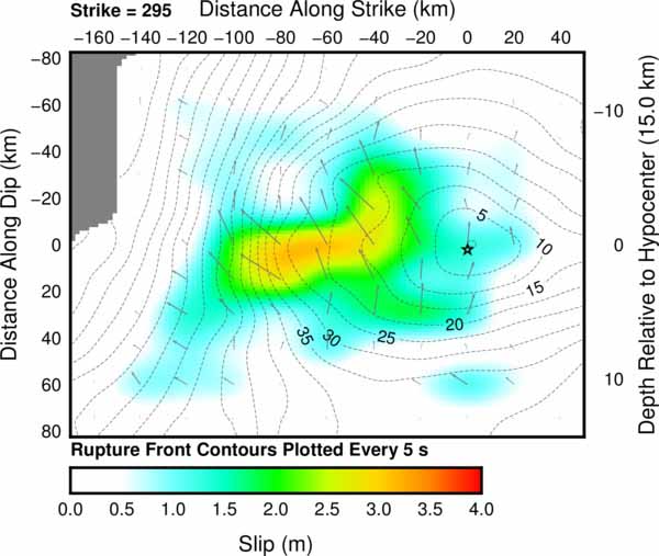
Slip Distribution.
|
|
|
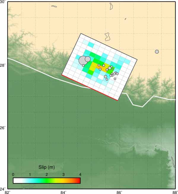
Surface projection of the slip distribution superimposed on GEBCO bathymetry. Thick white lines indicate major plate boundaries. Gray circles, if present, are aftershock locations, sized by magnitude.
|
Cross-section of slip distribution. The strike direction is indicated above each fault plane and the hypocenter location is denoted by a star. Slip amplitude is shown in color and the motion direction of the hanging wall relative to the footwall (rake angle) is indicated with arrows. Contours show the rupture initiation time in seconds.
|
To determine the movement along the fault have been used the following data:
- GSN broadband waveforms downloaded from the NEIC waveform server including:
a) 42 teleseismic broadband P waveforms;
b) 15 broadband SH waveforms;
c) 62 long period surface waves selected based on data quality and azimuthal distribution.
Waveforms are first converted to displacement by removing the instrument response and are then used to constrain the slip history using a finite fault inverse algorithm (Ji et al., 2002).
In modeling were used the following inputs:
- a hypocenter matching or adjusted slightly from the initial NEIC solution (Lon. = 84.7 deg.; Lat. = 28.2 deg., Dep. = 15.0 km);
- a fault plane defined using either the rapid W-Phase moment tensor (for near-real time solutions), or the GCMT moment tensor (for historic solutions).
After comparing waveform fits based on the two planes of the input moment tensor, finded that the nodal plane (strike= 295.0 deg., dip= 10.0 deg.) fits the data better. The seismic moment release based upon this plane is 8.1e+27 dyne.cm (Mw = 7.9) using a 1D crustal model interpolated from CRUST2.0.
To Top
India plate and Eurasia plate collision.
Nepal 2015 earthquake is the result of an ongoing collision the Indian lithospheric plate drifted northward and collided with the Eurasian plate that started more than 50 million years ago.
![India plate and Eurasia plate collision. [P. Molnar, 1986; Illustration by Ian Worpole]. India plate and Eurasia plate collision. [P. Molnar, 1986; Illustration by Ian Worpole].](images1/Nepal-2015/Nepal-2015_Himalaya-collision.jpg)
Himalayas were formed when the Indian lithospheric plate drifted northward and collided with the Eurasian plate. The collision is shown here in simplified, vertically exaggerated diagrams.
1. Approximately 60 million years ago, the oceanic lithosphere of the Indian plate was being subducted under Eurasian plate (southern Tibet).
2. Magma rising above the Indian plate erupted from volcanoes and formed granite intrusions. Sediments and oceanic crust scraped off the descending plate piled up in an accretionary wedge, which created a forearc basin that trapped sediments eroded from Tibet. Sometime between 55 and 40 million years ago the two landmasses collided.
3. The Indian crust was too buoyant to plunge far under Tibet. As a result a new fault, the Main Central Thrust, broke through the Indian crust. Later motion continued along the fault.
4. A slice of Indian crust, topped by Paleozoic and Mesozoic sediments that had been deposited on the continental shelf, was thrust up onto the oncoming subcontinent. The accretionary wedge and the forearc sediments were thrust northward onto Tibet. (Much of this material has since been eroded away.) About 20 to 10 million years ago the Main Central Thrust became inactive. Since then India has slid northward along a second fault - the Main Boundary Fault.
A second slice of crust has been thrust up onto the subcontinent, lifting up the first slice. The two uplifted slices make up the bulk of the Himalayas; many of the peaks are capped by Paleozoic sediments.
The Indian plate bends slightly under the weight of the mountains, and the resulting trough, now filled with sediments, can be detected under the Ganges plain.
To Top
Sources of information:
D. Shanker, H. Paudyal and H. N. Singh (2011). Discourse on Seismotectonics of Nepal Himalaya and Vicinity: Appraisal to Earthquake Hazard. Geosciences 1(1): 1-15; doi: 10.5923/j.geo.20110101.01
Ji, C., D.J. Wald, and D.V. Helmberger (2002). Source description of the 1999 Hector Mine, California earthquake; Part I: Wavelet domain inversion theory and resolution analysis, Bull. Seism. Soc. Am., Vol 92, No. 4. pp. 1192-1207,
P. Molnar (1986). The Structure of Mountain Ranges. Scientific American, July 1986; Illustration by Ian Worpole.
1. Websites:
- http://www.scientificamerican.com/article/how-the-deadly-nepal-earthquake-happened-infographic
- http://earthquake.usgs.gov/earthquakes/eventpage/us20002926#general_summary
To Top
|

